
Practical guide / Regulations
Drone permissions in Luxembourg: what should you plan for a professional shoot?
Using a drone for filming does not automatically require an operational authorisation. The location, date and flight conditions determine which steps are needed.
Key points
A professional shoot may fall under OPEN without prior operational authorisation.
-
However, a red zone may require access permission or notification.
-
On the Géoportail, enable the UAS layers, locate the shoot’s GPS position and open the conditions for each zone the flight will cross.
-
Download the relevant annex, send the requested information to the correct contact and observe the stated notice period before flying.
The first question for an aerial shoot is not simply whether permission is needed. You need to establish what will fly, where, when and under which conditions. A wide shot of a building and a close tracking shot during an event raise different planning questions.
Does a professional shoot always require permission?
No. A professional shoot can fall within the OPEN category. The European framework classifies operations by risk, rather than automatically separating leisure and commercial activity. A shoot can therefore take place in OPEN. SeeEASA’s explanation of this risk-based approach.
Under OPEN, no prior operational authorisation or operational declaration is required by that category. This does not remove other requirements concerning pilot competence, drone characteristics, people on the ground and local restrictions.
It is important to distinguish operational authorisation, which relates to the operating framework, from permission to access a geographical zone, which relates to a particular area. The latter may be needed even for an OPEN flight.
Start with the exact location and date
An address alone does not describe the whole shoot. The take-off point, flight path, intended height and position of people also matter. Prepare a map reference and a few photographs of the site to discuss a specific route.
- LocationAddress, area and flight path.
- Geographical zoneConditions in force on the flight date.
- OperationDrone, people and category.
- RequirementsApplicable requests and coordination.
This sequence structures the assessment. It does not approve a flight: every step must be resolved before confirming the setup.
Check geographical zones on the official map
In Luxembourg, consult the official UAS geographical zones map. The DAC notes that manufacturers’ zones do not necessarily cover every restriction. A drone allowing take-off is therefore not evidence that the operation is authorised.
A zone may prohibit flight, require prior permission or require notification. Read its conditions and identify the named contact. Several restrictions may apply in the same place.
1. Enable the UAS layers
Under Layers → Catalogue → UAS geographical zones, check that the “Flight height from 0 to 50 m” and “Flight height from 50 to 120 m” layers are selected. The direct link above normally enables them. Check every height band your planned flight will cross: a shot at 80 metres also involves climbing from the ground. A base map without these layers is not enough.
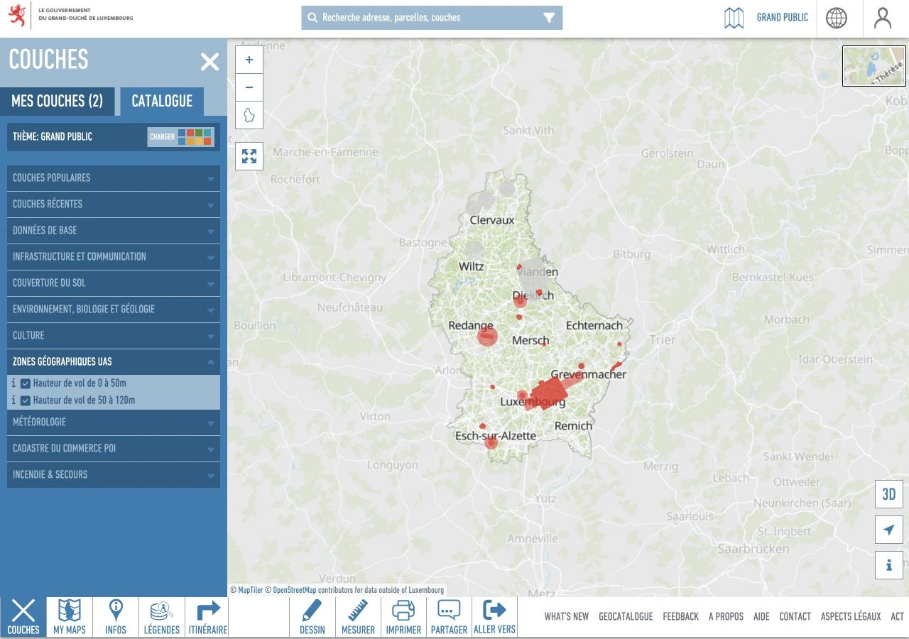
2. Locate the GPS point and open the red zone
Zoom in on the location, identify the GPS point from which you intend to take off, then click within the relevant red zone. The Info panel shows its reference, height limits, active period and the Conditionslink. Check the entire intended flight path as well: taking off outside a zone does not grant unrestricted entry into it.
Some red zones require specific permission, even under OPEN. Others, particularly around heliports, require notification and coordination. The zone’s document explains what applies; several zones may overlap.
- RedActive zone: check restrictions and access conditions.
- YellowZone due to become active shortly.
- GreyExisting zone that is inactive at the time of viewing.
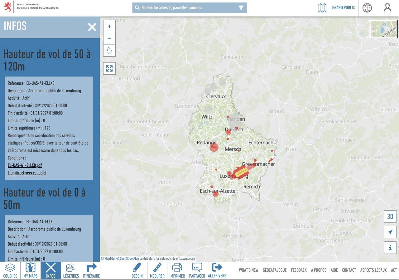
3. Download the annex and submit the request
Under Info → Conditions, open the PDF linked to the zone. It contains the access rules and, where applicable, the annex or form to complete. Note the zone reference and the contact details of the relevant authority.
- Provide the flight location : GPS coordinates in the requested format, the take-off point and the area covered by the route.
- Set out the flight plan : date, times, duration, height, drone and operator or pilot contact details, as required by the form.
- Send the application to the named recipient, with the requested documents and within that zone’s notice period.
- Before take-off, check the response and instructions : where authorisation is required, it must be obtained. A notification procedure may also require a phone call at the start and end of the flight.
The DAC Géoportail guide illustrates how to read a zone record and its form. Sending the document does not, by itself, authorise a flight. All conditions for the zones crossed must be met.
These screenshots explain how the tool works; they never replace the current map. Source: Géoportail Luxembourg, with map credits retained in the images. The DAC FAQ explains the colour coding.
The map is dynamic: some zones are activated several times a day, and temporary restrictions may be created for an event. A check made when quoting must be repeated before flying. The DAC geographical zones page also links to updates and explains these access conditions.
How much notice is needed for a red-zone request?
The notice period depends on the zone and the procedure. Read the annex before scheduling the shoot: notification periods are not interchangeable with authorisation request deadlines.
- At least 24 hoursFor the heliport notification shown in the DAC’s official guide. The record also requires telephone coordination on the day of the flight. Check your zone’s current annex.
- At least 10 daysThe ANA form for zone EL-UAS-A1-ELLX0 around Findel states this deadline and requires formal authorisation before the mission takes place.
- 10 working daysThe DAC’s stated minimum submission period for the UAS zone access requests it handles. Late, incomplete or complex requests may require more time.
Sources: DAC example of a 24-hour notification, ANA form EL-UAS-A1-ELLX0 and DAC submission deadlines, accessed on 22 September 2026.
These examples do not establish a single deadline for all red zones. The zone document, its recipient and the instructions received determine the exact procedure. Allow a margin and a backup date; retain the submitted application and the approval where required.
When can a shoot remain in the OPEN category?
OPEN includes the A1, A2 and A3 subcategories. The choice depends in particular on the drone and its proximity to people. Training requirements vary; the DAC overview of OPEN helps guide this check.
General criteria include a maximum take-off mass below 25 kg, no flight over assemblies of people, appropriate distances and maintaining visual line of sight under the applicable conditions. The general height limit is 120 metres from the closest point of the earth’s surface, subject to defined exceptions. The drone and operation must meet all conditions, not just the height limit.
These criteria appear in Articles 3 and 4 of the European regulation reproduced by EASA. They do not mean a small drone may film anywhere, or that private land is exempt from aviation rules.
OPEN: a shared framework in France and Luxembourg
The OPEN category applies in France, Luxembourg and the other EASA Member States : European Union countries, plus Iceland, Liechtenstein, Norway and Switzerland. Operator registration and the applicable European certificates are recognised across these countries, asEASA explains.
An operator registered in France therefore does not need cross-border operational authorisation for an OPEN mission in Luxembourg. Geographical zones and local rules still apply: access permission for a red zone may still be needed. The DAC FAQ confirms this distinction.
What if the shoot falls under SPECIFIC?
If a flight exceeds OPEN conditions, the operator must assess the SPECIFIC framework: operational authorisation, a European standard scenario declaration or LUC privileges, as applicable. The DAC sets out the relevant procedures.
The cross-border procedure here concerns SPECIFIC. A French operator must complete the applicable formalities in Luxembourg and obtain the required confirmations before the operation.EASA details the procedures for each operating framework. The DAC states a minimum of six weeks for an operational authorisation application and ten working days for a cross-border application. These lead times are separate from those for geographical zone access.
Remember ground filming and image rights
Airspace checks do not replace site coordination. Agree access, preparation areas, movement around the site and the available time slot with the site manager. Decide who can stop a take if someone enters the flight path.
Recording and publishing images is a separate matter. The DAC outlines privacy and personal data obligations. Identify anyone who may appear, the intended uses of the footage and the permissions to arrange with the production team.
Check professional drone insurance
Insurance suited to professional operations is part of shoot preparation. The DAC states that third-party liability insurance is mandatory for drones, to cover damage caused to third parties. Equipment damage cover does not replace this liability insurance.
Before the assignment, request a current insurance certificate and check with the insurer that the policy covers professional use, the planned drones and operations, and the country of filming — particularly Luxembourg for a French operator. Also check limits, excesses and exclusions. General liability or recreational insurance should not be assumed to cover paid aerial filming.
Information to share at the outset
For a useful initial assessment, gather:
- the exact location and the spaces you want to show;
- the date, time window and a possible fallback date;
- the shots you have in mind and your visual references;
- details of any public, crew or vehicle presence;
- the site manager’s contact details and access restrictions.
The drone filming in Luxembourg page explains how DB Studio can help. You can send the location and your filming brief so we can assess feasibility before the schedule is fixed.
Sources & verification
- DAC Luxembourg — OPEN category
- DAC Luxembourg — UAS geographical zones
- DAC Luxembourg — SPECIFIC category and lead times
- DAC Luxembourg — UAS applications and submission deadlines
- DAC Luxembourg — Géoportail guide and 24-hour notification example
- ANA — conditions and form EL-UAS-A1-ELLX0 (Findel)
- EASA — framework for drone operations
- EASA — Regulation (EU) 2019/947, Articles 3–5, June 2026 edition
- EASA — SPECIFIC operations in another state
- DAC Luxembourg — data protection
- DAC Luxembourg — FAQ: OPEN, insurance and geographical zone colours
- Géoportail Luxembourg — official UAS zone map
- EASA — registration, competence and operations in member states
Information last checked: .